Lost Courses of Yunnan   /   Lijiang Ancient Town Lakeside

Wenbihai · Yulong County · Lijiang

Lijiang Ancient Town
Lakeside

Lijiang Ancient Town Lakeside International Golf Club
丽江古城湖畔国际高尔夫俱乐部

Closed · Historical course profile

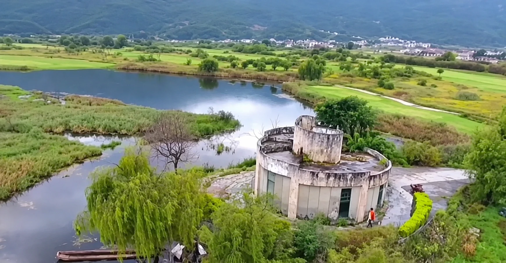
A round between mountain and water, with poetry at every hole. After golf ended beside Wenbihai Lake, former playing areas were replanted with trees and shrubs. Parts of the former grounds have also been used for wedding photography.

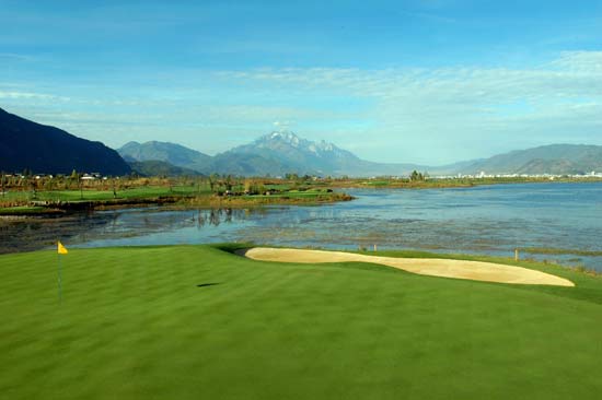
Historical golf landscape reflected in water, with Wenbi Peak and distant snowy mountains.
The former course beside Wenbihai · photographed before closureArchival photo: Sina Golf · 2007
Former layout
18 holesPar 72
Designer
Joe ObringerMountain and lakeside routing
Published length
7,661 yardsHistorical full-length layout
Golfing years
c. 2005–2018Closure recorded officially in 2019

The setting

Between Wenbi Peak
and the lake.

Snow mountains on the horizon. A lake at the heart of the round.

The club stood at Huangshan in Yulong County, about eight kilometres from Lijiang Old Town. Wenbi Peak rose behind the course, Naxi villages lay nearby, and views opened north towards Jade Dragon Snow Mountain. This was a different setting from the separate Jade Dragon course high at Ganhaizi.

Period descriptions place the course on roughly 1,200 mu of land—about 80 hectares—at more than 2,000 metres above sea level. Its character came from the meeting of hillside and shoreline: changes of elevation early in the round, then broader lake views as the routing reached the water.

English golf directories used several names, including Ancient Town Lakefront and Waterview Golf Resort. All refer here to the former Wenbihai club. The location’s scenery remains central to its story, even though its golfing chapter has ended.

One course, two landscapes.

Designed by Joe Obringer

Through the foothills

Front nine · Par 36 · 3,713 yards

The opening half climbed into the folds of the hillside. Doglegs, changes in level and strategically placed bunkers made positioning important. The fourth hole occupied the course’s high point, with wide views over the lake and surrounding mountains.

Along the water

Back nine · Par 36 · 3,948 yards

The return was flatter and more closely tied to the lakeshore. Water shaped the lines of play, while long holes and exposed approaches kept the challenge substantial. The seventeenth brought the lake directly into play across the tee shot.

Historical profiles describe Kentucky bluegrass fairways and bentgrass greens.

In the 2008 “My Favourite Golf Courses” awards, published in March 2009, the club featured among the winners for course quality, caddie service and resort golf.

Eighteen holes, eighteen verses.

The club paired each hole with Chinese verse, engraved on petrified-wood markers brought from Myanmar. The sequence connected a round of golf with ideas about ambition, perseverance, perspective and the passage through life. It gave the course a literary identity alongside its mountain-and-water setting.

Four holes to remember.

Archival photographs and illustrated hole plans

04

The mountain viewpoint

Par 3 · 170 yards
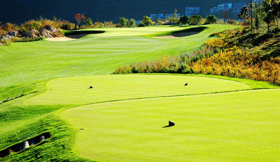
The fourth hole rising from its tee towards a green guarded by bunkers and rocks.
Hole 4 · archival photographArchival photo: Sina Golf · 2007
View the historical hole plan
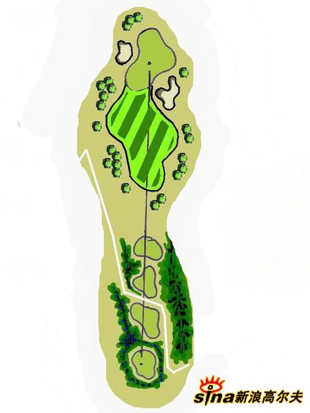
Historical illustrated plan of hole 4, showing the tees, fairway, bunkers and green.
Hole 4 · historical hole planIllustration: Sina Golf · 2009

A short hole at the highest point of the course. Bunkers and natural rock guarded a narrow, tiered green. Distance control mattered as much as direction: finding the correct level offered the best chance with the putter.

08

The long dogleg

Par 5 · 609 yards
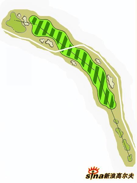
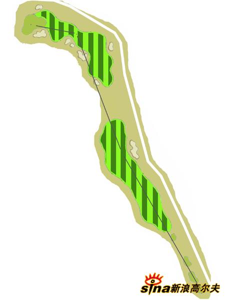
Historical illustrated plan of hole 8, showing the tees, fairway, bunkers and green.
Hole 8 · historical hole planIllustration: Sina Golf · 2009

This left-turning par five called for a plan across successive shots. Three fairway bunkers influenced the route, and the large, undulating green offered several possible approaches. Length alone did not settle the hole.

15

The longest test

Par 5 · 648 yards
Historical illustrated plan of hole 15, showing the tees, fairway, bunkers and green.
Hole 15 · historical hole planIllustration: Sina Golf · 2009

The longest hole on the published layout combined distance with a deep grassy hollow and an uphill approach. Front bunkers protected a multi-level green; the original guide favoured an approach from the right.

17

Across the lake

Par 3 · 182 yards
The seventeenth green beside Wenbihai, with its long bunker and mountain backdrop.
Hole 17 · archival photographArchival photo: Sina Golf · 2007
View the historical hole plan
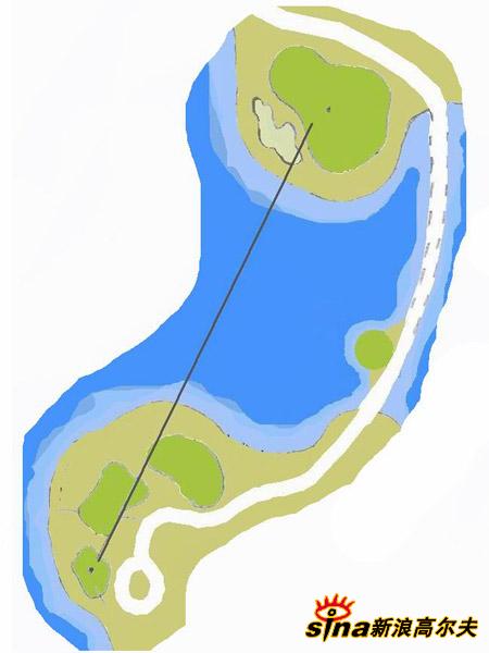
Historical illustrated plan of hole 17, showing the tees, fairway, bunkers and green.
Hole 17 · historical hole planIllustration: Sina Golf · 2009

A water carry to a peninsula green made this one of the course’s defining shots. A bunker guarded the front, with the lake surrounding the target. Wind could turn a modest yardage into a demanding decision.

Photographs of holes 4 and 17 were published in 2007. Holes 8 and 15 are shown using illustrated plans published in 2009; these are course diagrams, not photographs. Each image preserves its original appearance.

Explore the historical 18-hole layout · pars and yardages
Distances published in the 2007 hole-by-hole guide; historical reference only.
HoleParYards
14466
24365
34456
43170
54457
65585
73190
85609
94415
105641
114447
124442
133217
144475
155648
164429
173182
184467
Front nine363,713
Back nine363,948
Total727,661

A golfing chapter, now closed.

Construction, play and closure

2004

A contemporary account dates completion of the course’s construction to 26 November 2004.

2005

Trial play was planned for late 2005. English course directories give November 2005 as the opening date.

2018

Inspectors found the club operating in June. A suspension order followed on 28 June; a decision to shut the course permanently followed on 10 October.

2019

The national results, published on 19 July, recorded closure as completed under the Yulong Ecological Tourism Resort project name.

Why it closed

Golf within a
protected landscape.

An official environmental inspection identified 36 hectares of encroachment into the Wenbihai section of the Lashihai Plateau Wetland Provincial Nature Reserve. It also reported the use of reservoir land for golf infrastructure and deficiencies in environmental approval and pollution controls.

The club had received a stop order and a fine in September 2017, but inspectors found that operations had resumed. Later local reporting dates the comprehensive suspension order to 28 June 2018 and the permanent closure decision to 10 October. These are administrative milestones; the exact last round is not documented.

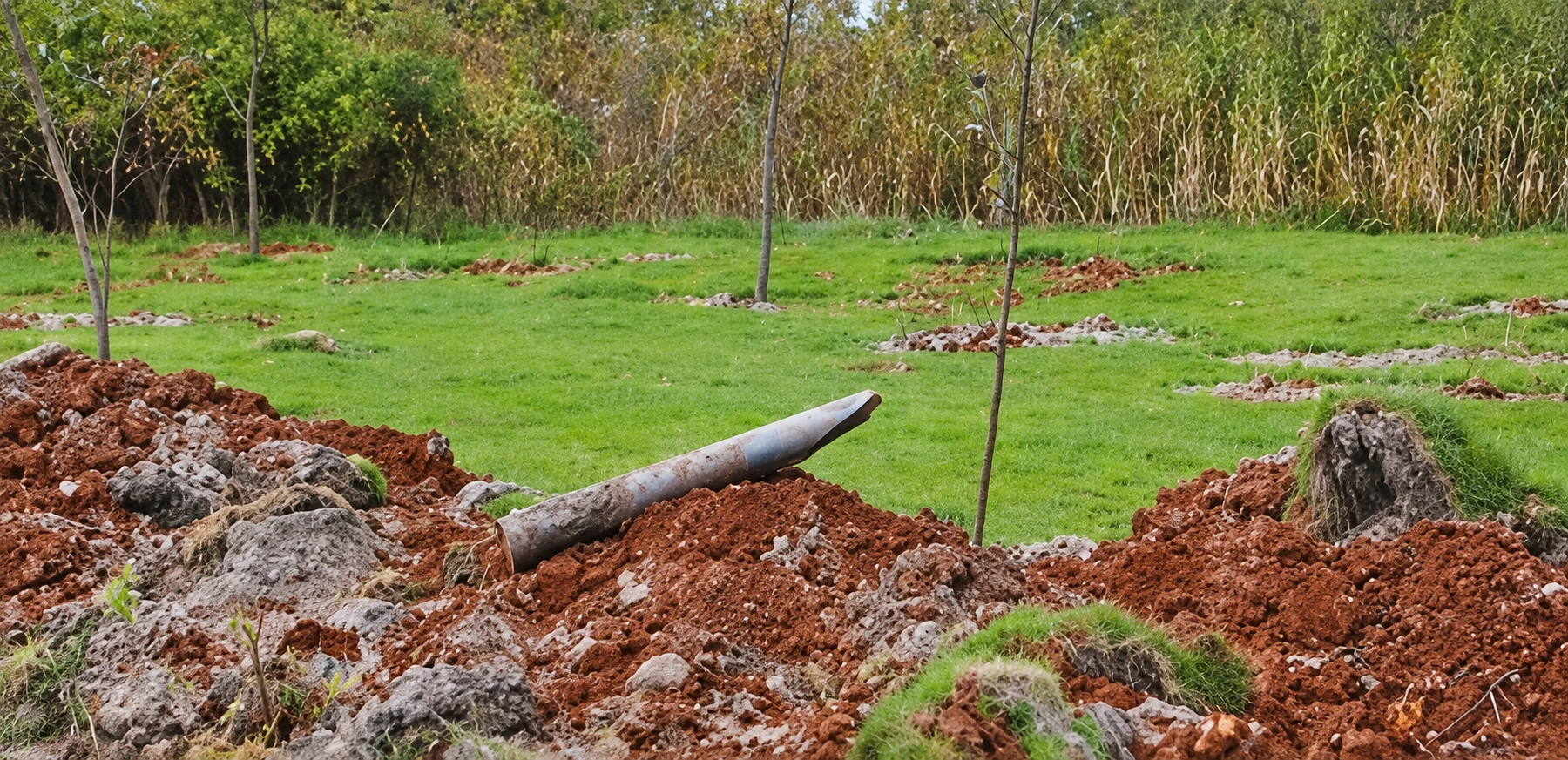
On 13 October 2018, CCTV-13’s Oriental Horizon (东方时空) examined the incomplete environmental clean-up. Its reporting described a course that had stopped operating, while facilities remained and workers continued tending the turf. It also challenged earlier official claims that the course had not occupied protected land. Stopping play had not yet removed the golf course from the landscape.

The national results published in July 2019 subsequently recorded the closure as completed.

View the official course closure record ↗

The transformation

When the golf
features disappeared.

October 2018 reporting recorded the removal of 72 teeing grounds, 18 greens and 73 bunkers, together with the underground turf-irrigation system. The work extended across playing areas inside and outside the protected-area boundary. Along that boundary, 3.5 kilometres of fencing separated the protected land.

Restoration brought rows of young trees, bamboo and shrubs to former playing areas. A report published in November 2018 recorded 6,687 trees, 1,920 clumps of arrow bamboo and 15,000 other shrubs planted by 18 October, alongside additional flowering plants and grasses. Species were selected with local soil and nearby natural vegetation in mind.

A further visit reported in December 2019 found trees where golf had once been played and no visible trace of the former tees, holes or bunkers in the areas inspected. Closure had become a physical transformation, rather than simply an end to bookings.

After golf

A new backdrop
for a different day.

Restored playing areas, and a later life in photographs.

Parts of the former grounds have since been used for wedding photography, with the lake and mountains providing a scenic backdrop. This later use sits alongside the documented restoration of former playing areas; it does not describe a single conversion of the entire course into one photography venue.

The precise extent of the photography areas is not established here.

About the former course

Is Lijiang Ancient Town Lakeside still open for golf?

No. It is a closed course, included here as a historical profile. Older travel and golf directory listings describe its playing years and should not be read as evidence that tee times are available.

Is this the Jade Dragon Snow Mountain course?

No. This club stood beside Wenbihai at the foot of Wenbi Peak. Jade Dragon Snow Mountain Golf Club at Ganhaizi is a separate course. The mountain appears in views from both settings, which can lead to confusion.

What other names did the club use?

Ancient Town Lakefront, Ancient Town International and Waterview Golf Resort appear in English descriptions. The official closure list uses 丽江市玉龙生态旅游度假区高尔夫球场—the Lijiang Yulong Ecological Tourism Resort golf course.

What occupies the former grounds now?

Former playing areas underwent ecological restoration, including tree planting and removal of golf infrastructure. Parts of the former grounds have also been used for wedding photography. This archive does not establish that the whole site became a photography venue, or provide visitor access and booking information.
There is more Yunnan golf to discover.

Explore the courses in our current guide, from Lijiang’s high mountains to the lakes around Kunming.

View current courses